Our footpath did not have any resemblance to the markings on the map. We
were on a zigzagging path, which was not shown, but there were little signposts
made of wood, pointing to Comine with figures carved such as 225 m and h 0.50.
After some deliberation we decided that the m referred to the height in metres
above the lake and the h.50 meant 50 minutes walking time. If country folk in
England minimise the time taken to follow their directions then the Italian
directions took on a more Latin temperament. We appeared to be taking between
two and three times the time allotted for our walk. This of course was caused
partly by our occasional stops to look at the scenery and the ancient buildings
remaining on the mountainside - many built from the surrounding rock with slated
roofs. The wooden doors had rotted and inside there was a hollow where once
there had been a wooden floor.
Our journey was to take us up to Chirac. We found the name on one of the
wooden signs but since it was rectangular with neither a right nor a left arrow
we concluded we had arrived. Why were there no houses? The only reassurance was
the sign pointing to Comine. We expected it to be the stop for a bus for our
return journey or a ferry down the lake back to Canerro.
Since lunchtime was close we had to make an important decision at a fork in
the path. Comine Sup. was higher than the community by the lake. Comine Inf.
held a brighter prospect for a restaurant. We made our way down past tumbling
waterfalls and smallholdings on the hillside.
The village seemed bereft of a suitable facilities; there being one
restaurant down by the waterside which was closed, and another at the side of
the road which clearly dated from previous centuries and had the toilet
facilities to match. The price of a meal, however, was the equivalent of £8
to £10 for lunch and £2 for an ice cream.
Walking along the main road was fraught with difficulties. There was no
pavement. This added to the sense of adventure unnecessarily since the Italian
drivers came speeding around the corners with inches to spare for the occasional
hiker. We made our way back to the footpath having determined that the town was
too small to justify a ferry back to Canerro. Rather than wait about an hour for
a bus we took the mountain path again. The signpost had indicated a prospective
historic site called Villagio Millenia. There was a moment of confusion when we
were confronted with a shrine but on reaching the corner we found a concealed
right-hand turn which led up the mountainside. It is of course recommended that
one should get out of breath for at least 10 minutes three times a week and so
our climb up the mountain side was beneficial.
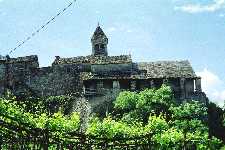
We arrived at Comine Superior to find Villagio Millenias. It started off as
a fort in 975 AD when people from the lakeside went there for refuge after being
attacked by people from other states further South. The dwellings and church
were built in the grounds of the fort about 1300. Shorn out of the cliff side it
represented the massive effort that seems common with these buildings of former
times. No doubt, the peasantry were encouraged to perform the backbreaking toil
necessary to build these edifices. The church was not open and parts were railed
off where wooden ramps, now rotted, had supported people walking over the sheer
drop at the side of the church. There is a magnificent view from the courtyard
over Lake Maggiore.
Having climbed to Comine Sup we had a gentle walk down to the fork and
rejoined the path back to Canerro. We were conscious how long it had taken us
and checked on the time - less distracted by the views and buildings we had seen
previously. It is fair to say that, when stepping out with purpose, the journey
can be made in the times indicated on the signposts but we would advise the
casual tourist to multiply them by 2 to 2.5 to estimate their time of arrival.
Many of the steep parts of the path were punctuated by steps made from boulders
quarried out of the mountainside. Whilst this doubtless kept the path intact
during flooding it could be slippery for leather shoes and a twisted ankle might
be a hazard.
A difficulty of the area is that the guidebooks are usually in Italian or
German. This is in keeping with the fewer numbers of English visitors at our
hotel. In some parts the waiters did not speak English, but French was sometimes
a mutual language.
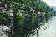
For the remainder of our holiday we took the ferry to the many waterside
villages. It was a more relasing way to travel. |